Biodiversity

Check out the information below to learn more about biodiversity initiatives happening in Baw Baw Shire, both Council and community led.
Join the Biodiversity Blitz this September!
September is biodiversity month and to celebrate, Council is taking part in the Biodiversity Blitz and you're invited to get involved and join Baw Baw's biggest citizen science project to date!
The Biodiversity Blitz is all about getting out in nature and recording as many plant and animal species as possible during the month of September.
The project isn't only fun, but helps identify the diversity of flora, fauna, and fungi found in Baw Baw - plus you'll be flying the flag for Baw Baw and competing with other Shire's in a little friendly competition to see who can record the most species!
All you need to do is download the iNaturalist App for iOS or Android and register to be part of Team Baw Baw to make sure your discoveries are counted! Click on the icon below to register.

Learn how to use the iNaturalist App with this tutorial form Dr Luis Mata.
It's never been easier to be a citizen scientist!
Explore the new online and interactive Baw Baw Biodiversity poster
Friend's of Drouin's Trees have turned the Baw Baw Shire biodiversity poster into an online hub of environmental knowledge for all to enjoy!
The interactive poster now contains images and information on all 56 species featured in the poster, which can be accessed with just the click of a mouse!
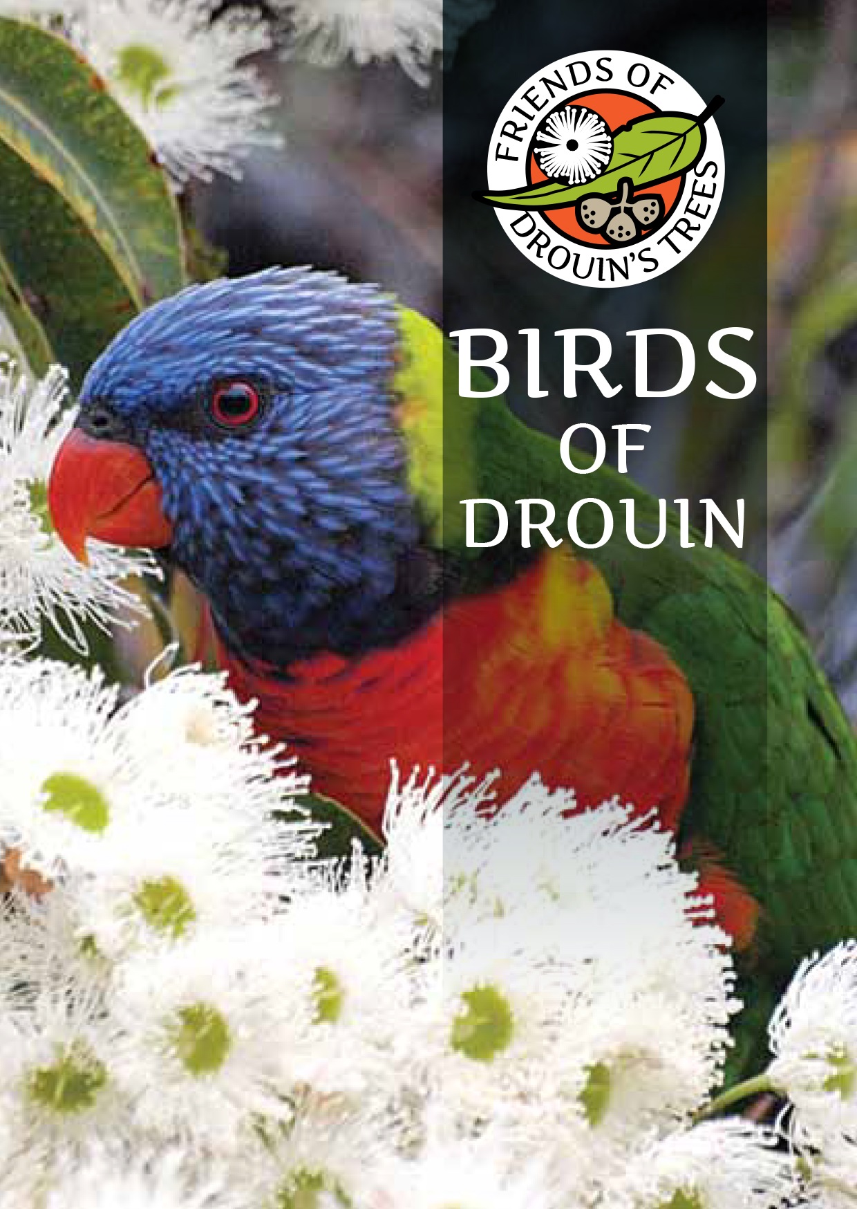
You can also access the Friends of Drouin's Trees Birds of Drouin and Drouin Tree Walk books, the Significant Tree Register, pages on bird surveys and much more.
Click here to launch the interactive page
Inspired to get out there and spot some wildlife?
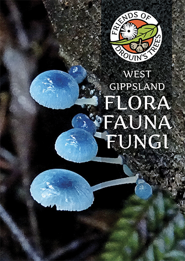
Friends of Drouin's Trees have created three books identifying the numerous bird life, flora, fauna and fungi that call the Drouin and West Gippsland areas home. You can download a printable version of each book below, or purchase a hard-copy in many local retailers.

Biodiversity Plans and Initiatives
Learn more about some of our biodiversity plans and initiatives below.
Urban Planning and Development
Biodiversity assets and values within the urban growth areas of Warragul, Drouin, Trafalgar and Longwarry have been assessed and mapped as part of Council’s 2011 Biodiversity Assessment and Mapping of Urban Growth Areas. This information has been used to prepare Council’s Settlement Strategy (C104) as well as the biodiversity components of both the Warragul and Drouin Precinct Structure Plans (C108). Council intends to prepare Urban Design Frameworks for both Longwarry and Neerim South in the near future.
Initiatives for Management of Biodiversity Assets include:
- Council’s Environment and Climate Change Strategy was approved in October 2011. This strategy addresses themes on biodiversity, climate change, land and water management and transition to a low carbon economy.
- Key Council nature reserves and their biodiversity assets and values have been identified and assessed. Management plans have been completed for Nangarra, Robin Hood, Rokeby Flora and Fauna and Thornels Reserves.
- Council is currently revising its Roadside Management Plan. The draft revised Plan (now titled Roadside Conservation Management Plan) provides more information and better guidance about the management requirements of significant native vegetation and habitat on roadsides management by Council.
- In partnership with the West Gippsland Catchment Management Authority, Council has drafted a Waterway Management Plan Guideline 2014 for use by Council and developers when planning for development and management in and around waterways.
- Council is currently preparing guidelines for incorporating habitat of the threatened Warragul Burrowing Crayfish into the design of existing and proposed wetlands and retardations basins. These guidelines will assist both Council and developers when managing existing or planning for new storm water treatment utilities.
- In partnership with Melbourne Water, Council has sourced guidelines for incorporating habitat of the threatened Dwarf Galaxias fish into the design of existing and proposed wetlands and retardations basins. These guidelines will assist both Council and developers when managing existing or planning for new storm water treatment utilities.
Native Vegetation Offset Scheme (NVOS)
Baw Baw Shire Council commenced operation of its NVOS in December 2012 to address a lack of third-party offsetting opportunities for developers seeking offsets in Baw Baw and to streamline the process for offset acquisition for permit holders (link to NVOS fact sheet).
Vegetation credits derived from two established offset sites located at Trafalgar and Lardner Transfer Stations have been successfully used to supply offset credits to permit holders since commencement of the Scheme.
On the 20 December 2013, the Victorian Government revised the native vegetation removal provisions, incorporating the permitted clearing of native vegetation – Biodiversity assessment guidelines (the Guidelines) into the Planning Scheme.
The revised Guidelines have introduced a new vegetation currency (Biodiversity Equivalence Units) to facilitate the trade of offsets
In September 2014, Council approved commencement of trading by Council’s NVOS in the new vegetation currency (Biodiversity Equivalence Units) for an initial period of six months.
Council’s NVOS has continued to trade in native vegetation credits identified under the old native vegetation removal provisions (Victoria’s Native Vegetation Management – A Framework for Action 2002) for permits issued prior to incorporation of the new Guidelines in December 2013.
Giant Gippsland Earthworm Environmental Significance Overlay 4 (ESO4).
The Giant Gippsland Earthworm Overlay was gazetted in May 2012 (C81). This amendment incorporates a Giant Gippsland Earthworm Environmental Significance Overlay into the Planning Scheme. This overlay appears on the planning scheme maps as ESO4 - Environmental Significance Overlay 4.
To accompany the Overlay, Council has prepared a Planning Scheme Reference Document (Giant Gippsland Earthworm Environmental Significance Overlay June 2011), informing landholders, developers, planners and consultants about the Giant Gippsland Earthworm and use of the Environmental Significance Overlay. Council has also revised the Municipal Strategic Statement (Clause 21.07-2 – Biodiversity) to reflect the amendment.
A revision of Schedule 4 to the Giant Gippsland Earthworm Environmental Significance Overlay was gazetted in October 2014 (C108). The revision resolves a number of minor buildings and works issues within the habitat of Giant Gippsland Earthworm to improve and streamline the efficiency of the ESO4.